In September 2025, the Gainesville City Commission directed staff to reimagine the Thelma Boltin Center site in a manner that honors Thelma Boltin’s legacy, acknowledges the site’s World War II history and reflects community identity. The redevelopment is expected to incorporate usable outdoor community space, stormwater improvements and the continuation of the community garden. A robust public engagement process is currently underway to ensure that the final vision reflects community identity and responds to local needs.
Additionally, the the site will serve as a trailhead for the Sweetwater Trail Loop System. The “Sweetwater Greenway,” will connect Depot Park, the Matheson History Museum and the Sixth Street Rail-Trail, linking multiple established neighborhoods with parks, cultural amenities and nearby commercial areas.
The site plan for the park and trailhead is funded for $2M through Wild Spaces & Public Places and the use of Stormwater and Tree Mitigation Funds.
In late 2025, the Wild Spaces & Public Places Department contracted NV5, Inc. to develop conceptual designs for both the site improvements and the trail alignment, with the goal of presenting concepts for City Commission approval in fall 2026.
This project is currently in the planning phase.
Site Information
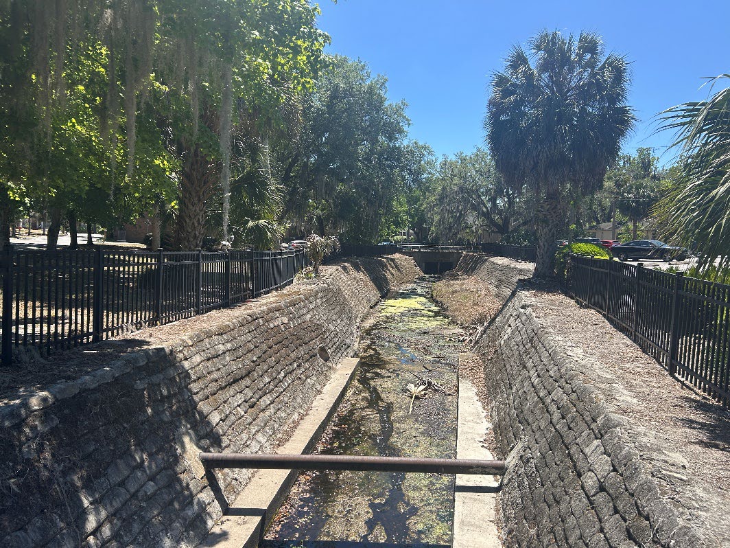
The main project site encompasses approximately 2.2 acres and is composed of two parcels in downtown Gainesville. The northern parcel currently includes a community garden, a dumpster facility serving Bo Diddley Plaza, and accessory parking. The southern parcel functions primarily as surface parking. Northeast Second Avenue bisects the two parcels, creating a division in site access and circulation. The Sweetwater Branch Creek makes up the eastern boundary of both parcels, and a portion of the site is located within the FEMA 100-Year Floodplain (Zone A). Hydrologic modeling and analysis will assess upstream stormwater drainage concerns and determine the feasibility of floodplain storage and restoration onsite.
For the trail alignment portion of the project, the Sweetwater Greenway Trail will connect from University Avenue through the Duckpond neighborhood to the Sixth Street Rail-Trail.
Existing Condition Images
Please see below for images of the project site's existing conditions.
The Wild Spaces & Public Places Department believes public engagement plays a key role in successful community projects. A robust public engagement process is currently underway to ensure that the final vision reflects community identity and responds to local needs.
Community Workshop #1 - June 30, 2026
Workshop Summary
Staff hosted Community Workshop #1 on June 30, 2026 at the Thomas Center to gather feedback and input regarding future project planning, landscaping and design decisions for the Thelma Boltin Trailhead and Sweetwater Greenway Loop Trail Alignment project.
Approximately 44 people attended the event and provided feedback throughout the evening. The format of the workshop involved a presentation, Q&A session, a digital poll and public discussion. The digital poll — with paper copies available as an alternative to the digital platform — allowed participants to provide input on what they'd like to see at the new trailhead and park.
Staff also invited attendees to provide input in the form of various interactive boards. One of the boards asked participants to choose between two "image boards" and describe what type of design approach they preferred. Another board encouraged participants to share features of parks and trailheads they've enjoyed in the past. Additionally, attendees utilized a project site map to identify potential flooding and drainage concerns. As with all Wild Spaces & Public Places workshops, staff provided index cards for any additional written comments and were available for in-person questions after the presentation concluded.
Workshop Materials and Documents
Community Workshop #2 - To Be Scheduled
Staff are currently working to select a date and location for the next community workshop. Attendees can expect to see initial site plans and potential trail alignments during this upcoming workshop.
Community Workshop #3 - To Be Scheduled
Pending the results and feedback of the second community workshop, a third community workshop will be scheduled for the public to review plans at a more developed phase of the project.
The project site is the former location of the Thelma A. Boltin Center, originally known as the Gainesville Servicemen's Center. Built in 1942, the center served as an entertainment venue for U.S. service members stationed at nearby military bases. The City of Gainesville purchased the facility in 1946 and later converted the building into a multipurpose facility managed by the Department of Parks, Recreation and Cultural Affairs. It was renamed in honor of the center's first director, Thelma A. Boltin.
Scanned postcard of the Thelma Boltin Center.
Servicemen playing piano, reading and conversing at the Thelma Boltin Center.